{"_id":"@abovesurveying/leaflet-measure","_rev":"3-89c2aaff093e601c70dae94130f12f8f","name":"@abovesurveying/leaflet-measure","dist-tags":{"latest":"3.1.1"},"versions":{"0.0.0":{"name":"@abovesurveying/leaflet-measure","version":"0.0.0","description":"Coordinate, linear, and area measure tool for Leaflet maps","main":"dist/leaflet-measure.js","repository":{"type":"git","url":"git+https://github.com/abovesurveying/leaflet-measure.git"},"keywords":["leaflet","measure","measurement","control","coordinate","line","length","area","polygon","path"],"author":{"name":"LJA Engineering, Inc - GIS","email":"gisdev@ljaengineering.com"},"contributors":[{"name":"Jack Starkey, Above Surveying","email":"jack@abovesurveying.com"}],"license":"MIT","scripts":{"lint":"eslint --ext js src/","build":"webpack --config webpack.prod.js -p","start:dev":"webpack-dev-server --open --config webpack.dev.js","precommit":"lint-staged","prepublishOnly":"yarn build","ghpages":"yarn build && gh-pages -d dist"},"lint-staged":{"*.js":["eslint"],"*.{js,scss}":["prettier --write","git add"]},"dependencies":{"@turf/area":"^5.1.5","@turf/length":"^5.1.5"},"devDependencies":{"babel-core":"^6.26.0","babel-loader":"^7.1.2","babel-preset-env":"^1.6.1","babel-runtime":"^6.26.0","copy-webpack-plugin":"^4.4.1","css-loader":"^0.28.9","eslint":"^4.17.0","eslint-plugin-import":"^2.8.0","extract-text-webpack-plugin":"^3.0.2","gh-pages":"^1.1.0","glob":"^7.1.2","html-loader":"^0.5.5","husky":"^0.14.3","lint-staged":"^6.1.0","node-sass":"^4.7.2","prettier":"^1.10.2","sass-loader":"^6.0.6","style-loader":"^0.20.1","webpack":"^3.10.0","webpack-dev-server":"^2.11.1"},"peerDependencies":{"leaflet":"^1.0.0"},"gitHead":"a78b13bc0ef9f2d88127c7747db90e695e72f7d6","bugs":{"url":"https://github.com/abovesurveying/leaflet-measure/issues"},"homepage":"https://github.com/abovesurveying/leaflet-measure#readme","_id":"@abovesurveying/leaflet-measure@0.0.0","_nodeVersion":"14.15.3","_npmVersion":"6.14.9","dist":{"integrity":"sha512-DDzx3WffMrR2Gafbv/JZI2Fyg2gGmbOKPTPU8zkcMIlfeUxRke80kGOgVxM9s62WLayxqR25l3R3bwrj+wZSbw==","shasum":"71d075f3d8ff245fcecad60e15933203f0aa8dd1","tarball":"https://registry.npmjs.org/@abovesurveying/leaflet-measure/-/leaflet-measure-0.0.0.tgz","fileCount":62,"unpackedSize":1594918,"npm-signature":"-----BEGIN PGP SIGNATURE-----\r\nVersion: OpenPGP.js v3.0.13\r\nComment: https://openpgpjs.org\r\n\r\nwsFcBAEBCAAQBQJgdDtcCRA9TVsSAnZWagAACXIP/1/6RLBTLYk2BxjhWxR1\naVuMa2lxOFTVgHA69GB+Rxn0in/C/BynAb2dNnJkmWyfIiWO8Kk3IbwGY2iX\nYjRBFJr914oiCfWFWGpVqExAfkZmFKQ0yvqDztB9fNAsDDg722YYAg97RAUT\nuJoSsv4wqmbLYxCu/Oapi3e+/0Kupl+hoREhxBaC+R6OA3wRncN3wmqRKazI\nsXqd2o+DaWooUialdTPi58wC0LgwZqOLJlQ6xO1EetZqEAS/y236iItHB8J/\n+FzKiVOM/IR+3wkaIaTzWy6/C+Y1ahv4uW2nooqvOhzgNPPbmv+mKYLa+Q52\n6j9dM72r2xlxKOaj/shyTOzkQzlJ8h0+PheIjGY5qAWtw3Ili4ZYTniCbsle\nbZllOroNmDU2IVUL3ejMjYu98JRyRl7L5kVQ646ZHCdn11uOsUhri3u4gHDA\nBY44+6mAT0dFYdplGbWQeiTue3z3V/G+sztcJ85VKksLI3ps08ErF35U2t2m\nDbT+DGRehsmaA2kq9wOtxOseZkEOlxd+qozSK/SbyMy2gWrEEHiEmYLL4ygE\npRY9m2KDLJDzCNkE+pxD4R3o6qXzjuY7DApNBN5io+HXiTYdXlht3bqBjvs1\n6EzHgVHrRtWhok7BTE/SiEQFm4DpJiXqQtqgbvlkpDMrKVpP6XHbUlRW/uWh\n8EdJ\r\n=LT18\r\n-----END PGP SIGNATURE-----\r\n","signatures":[{"keyid":"SHA256:jl3bwswu80PjjokCgh0o2w5c2U4LhQAE57gj9cz1kzA","sig":"MEYCIQDJ0vDZ+41/8wM8q7I9ACvi35O7TRAC+ba7ZM8WUbB2mAIhAKQEA3ADp+RcQIsSfMvfdEOfMJdu4xxGO6aKKcMtZ1jU"}]},"_npmUser":{"name":"above-jack","email":"jack@abovesurveying.com"},"directories":{},"maintainers":[{"name":"above-jack","email":"jack@abovesurveying.com"}],"_npmOperationalInternal":{"host":"s3://npm-registry-packages","tmp":"tmp/leaflet-measure_0.0.0_1618230107472_0.6437085134240637"},"_hasShrinkwrap":false},"3.1.0":{"name":"@abovesurveying/leaflet-measure","version":"3.1.0","description":"Coordinate, linear, and area measure tool for Leaflet maps","main":"dist/leaflet-measure.js","repository":{"type":"git","url":"git+https://github.com/abovesurveying/leaflet-measure.git"},"keywords":["leaflet","measure","measurement","control","coordinate","line","length","area","polygon","path"],"author":{"name":"LJA Engineering, Inc - GIS","email":"gisdev@ljaengineering.com"},"contributors":[{"name":"Jack Starkey, Above Surveying","email":"jack@abovesurveying.com"}],"license":"MIT","scripts":{"lint":"eslint --ext js src/","build":"webpack --config webpack.prod.js -p","start:dev":"webpack-dev-server --open --config webpack.dev.js","precommit":"lint-staged","prepublishOnly":"yarn build","ghpages":"yarn build && gh-pages -d dist"},"lint-staged":{"*.js":["eslint"],"*.{js,scss}":["prettier --write","git add"]},"dependencies":{"@turf/area":"^5.1.5","@turf/length":"^5.1.5"},"devDependencies":{"babel-core":"^6.26.0","babel-loader":"^7.1.2","babel-preset-env":"^1.6.1","babel-runtime":"^6.26.0","copy-webpack-plugin":"^4.4.1","css-loader":"^0.28.9","eslint":"^4.17.0","eslint-plugin-import":"^2.8.0","extract-text-webpack-plugin":"^3.0.2","gh-pages":"^1.1.0","glob":"^7.1.2","html-loader":"^0.5.5","husky":"^0.14.3","lint-staged":"^6.1.0","node-sass":"^4.7.2","prettier":"^1.10.2","sass-loader":"^6.0.6","style-loader":"^0.20.1","webpack":"^3.10.0","webpack-dev-server":"^2.11.1"},"peerDependencies":{"leaflet":"^1.0.0"},"gitHead":"06a786a2d74cf02662afe16ebacdf047f79b852a","bugs":{"url":"https://github.com/abovesurveying/leaflet-measure/issues"},"homepage":"https://github.com/abovesurveying/leaflet-measure#readme","_id":"@abovesurveying/leaflet-measure@3.1.0","_nodeVersion":"14.15.3","_npmVersion":"6.14.9","dist":{"integrity":"sha512-YH0+Ru+Pla9/RhWn+6C3oGntyKYmeGO0aOCAagE97FJHTMYUmVYbWNeQ6nfgnyeI+hOJbRJnVMOWXOv8/7Guzg==","shasum":"b036ac9e455cdad4628b2a8a6f2e7c9b9de0aebb","tarball":"https://registry.npmjs.org/@abovesurveying/leaflet-measure/-/leaflet-measure-3.1.0.tgz","fileCount":62,"unpackedSize":1594918,"npm-signature":"-----BEGIN PGP SIGNATURE-----\r\nVersion: OpenPGP.js v3.0.13\r\nComment: https://openpgpjs.org\r\n\r\nwsFcBAEBCAAQBQJgdD+oCRA9TVsSAnZWagAAzzcP/iOpGiUvVSF6rH3UHYgO\niIfnzKmCZizY3L0XoU5+oPJ2x93FmwZjbJN8UUkBaKghfIO6V7s3dxk1rCgC\n9AV0rc1zYaPVY+AzaSil0y+W7Nargp7e3+EI5g9tlGktXVFBdgE4uh3svouR\nIXoIL11AVKrtUBTTL0lx/a8V37//na9TpoLzNPSwqtgAGrQfFK//pR2ARhsf\ng6YJzpTP/7jCf/zi1dWTJ/3WO1bGVaIkZkVJHsNj9TlLLmVgr5HtjiL4I6e1\n2G+C0KZWaUypXHmSU4hbW9RtJo7AWATlcnIlIYaw9aFb3Nfi6zJEF4aILmyE\nHTgko+0B82xaPzO9+Ng+g/c+nAB4ynacgFIxkRi5KMs8QYFQWeOC5zny5CiM\nFsWSFjljB5iikGccL1VqSGpZR134hFSnO5BJI5DZ8hjQEcAj/zwhh4kkWQrr\nollwt336bY5xuZYUWv2sXYC9qil1/LeqcvafO0ArrPUUmqG6pALH35/DU2Xk\nfMkNYodpK+W2La1DRSlZRNUDLeWatBoDzSPoO+0vLJl/NsOOWoO5QbMjxoy1\n+fdl1L1c0UIDpsXLsbOX/HRL1mw+AP+SZTOx1t5bVbJgZcIZVol5jVScwyqU\n2bpc6iAKKQZuCQ/eksiaWi+1xei6aG58jWEDQ/GkbWaoMzko5BKgpQ/GWMyI\nsawW\r\n=mjzz\r\n-----END PGP SIGNATURE-----\r\n","signatures":[{"keyid":"SHA256:jl3bwswu80PjjokCgh0o2w5c2U4LhQAE57gj9cz1kzA","sig":"MEQCIHjvtlFWH+EMUgDtz9Nj7cfAjZN3nTCwTx2veSYTiEFpAiAK0w5A7ISpn9BJTcCgqORa9l+vjReMzTekVBVTDOp36A=="}]},"_npmUser":{"name":"above-jack","email":"jack@abovesurveying.com"},"directories":{},"maintainers":[{"name":"above-jack","email":"jack@abovesurveying.com"}],"_npmOperationalInternal":{"host":"s3://npm-registry-packages","tmp":"tmp/leaflet-measure_3.1.0_1618231207993_0.05730046905933284"},"_hasShrinkwrap":false},"3.1.1":{"name":"@abovesurveying/leaflet-measure","version":"3.1.1","description":"Coordinate, linear, and area measure tool for Leaflet maps","main":"dist/leaflet-measure.js","repository":{"type":"git","url":"git+https://github.com/abovesurveying/leaflet-measure.git"},"keywords":["leaflet","measure","measurement","control","coordinate","line","length","area","polygon","path"],"author":{"name":"LJA Engineering, Inc - GIS","email":"gisdev@ljaengineering.com"},"contributors":[{"name":"Jack Starkey, Above Surveying","email":"jack@abovesurveying.com"}],"license":"MIT","scripts":{"lint":"eslint --ext js src/","build":"webpack --config webpack.prod.js -p","start:dev":"webpack-dev-server --open --config webpack.dev.js","precommit":"lint-staged","prepublishOnly":"yarn build","ghpages":"yarn build && gh-pages -d dist"},"lint-staged":{"*.js":["eslint"],"*.{js,scss}":["prettier --write","git add"]},"dependencies":{"@turf/area":"^5.1.5","@turf/length":"^5.1.5"},"devDependencies":{"babel-core":"^6.26.0","babel-loader":"^7.1.2","babel-preset-env":"^1.6.1","babel-runtime":"^6.26.0","copy-webpack-plugin":"^4.4.1","css-loader":"^0.28.9","eslint":"^4.17.0","eslint-plugin-import":"^2.8.0","extract-text-webpack-plugin":"^3.0.2","gh-pages":"^1.1.0","glob":"^7.1.2","html-loader":"^0.5.5","husky":"^0.14.3","lint-staged":"^6.1.0","node-sass":"^4.7.2","prettier":"^1.10.2","sass-loader":"^6.0.6","style-loader":"^0.20.1","webpack":"^3.10.0","webpack-dev-server":"^2.11.1"},"peerDependencies":{"leaflet":"^1.0.0"},"gitHead":"500362144a43b0c49207f72d61bbf5ba388fef3d","bugs":{"url":"https://github.com/abovesurveying/leaflet-measure/issues"},"homepage":"https://github.com/abovesurveying/leaflet-measure#readme","_id":"@abovesurveying/leaflet-measure@3.1.1","_nodeVersion":"14.15.3","_npmVersion":"6.14.9","dist":{"integrity":"sha512-BDs2li8KBBvuEvGM/1E2C5w/+hXe4rQr3bi61rr6wMA+r+RcpxDMU2VwfLjxLJ7U6d7Wh4BFXUuA1L7djX0tUw==","shasum":"4636a2c1b2265fa060aa62459206a056eca83981","tarball":"https://registry.npmjs.org/@abovesurveying/leaflet-measure/-/leaflet-measure-3.1.1.tgz","fileCount":60,"unpackedSize":1564308,"npm-signature":"-----BEGIN PGP SIGNATURE-----\r\nVersion: OpenPGP.js v3.0.13\r\nComment: https://openpgpjs.org\r\n\r\nwsFcBAEBCAAQBQJgdGhVCRA9TVsSAnZWagAAF/IP/16PP6k5upHz0BZU/vFF\nbwV+dUg2f6mxOHRhLtIYjYZiHhCivPA7G4ELyvwy/PoNZLeA6KEfLKS66jCI\nViLaGAqF+ol9xTUgwCsrXCDWxHSrTjKguVEcbyb1KG6oikdcAX020Lm6pyBC\nZLWGuzIIlwv4Gq+FA0cT2zBy4brsBGfcEfUlgNG3EGyDzC2JTrbH+D0uBFUr\nRovj7e216xle5tZT2vijjzy9yZ7zWU/dmiAtyLFNoSN5id7bi/Pc1NuK3jqj\nuZKY4oXD9k9+9/aBZW0vXWhhccddaOLURM2S3ZXFxBVOFp8w+OugI8EE0/Z1\nTG1uBpI7M5EsJLl1w67Kqa+7oy2mwfleU01bfFJIid7QIjLDdB7ceREZl2VK\nvOv8mCiqT6wpkvJzuOWZ1RcckXKp4RCJ1ibO4PQ++qCxW2P+tuM6l/DvWXWp\nntcarSyiq/sbFuTSmwVcJFOCY/odINhmhTlYKlgeFW6c3SGnK+zTvqZITiXA\n8d/JlfnQ3w32TnNKMzTQUeueIMZBOZQ17gnbs+2FI2ey5YIcj11Rpw6cAW1N\nPVpdbxf9Xhw8bVrhRKlkUt3F99KGuY17kfRwx5Bmc61zRkPWlbsQF3zm8ZmI\ntG+myH7/L7+GG+gbsbBQsOeDBsoB3tareoZTXcVP84sIKa6Sws80DY1TOvQZ\ntGJw\r\n=JJ/i\r\n-----END PGP SIGNATURE-----\r\n","signatures":[{"keyid":"SHA256:jl3bwswu80PjjokCgh0o2w5c2U4LhQAE57gj9cz1kzA","sig":"MEQCICG80Llb2xpy0S/3X3aaAsE6CtD6OcI0eD9m3KguKblRAiAfO8DnBpHV46/UBrelwmmPxDQdlKvWlIX6Hb8cLgcAbw=="}]},"_npmUser":{"name":"above-jack","email":"jack@abovesurveying.com"},"directories":{},"maintainers":[{"name":"above-jack","email":"jack@abovesurveying.com"}],"_npmOperationalInternal":{"host":"s3://npm-registry-packages","tmp":"tmp/leaflet-measure_3.1.1_1618241620626_0.07829557304849755"},"_hasShrinkwrap":false}},"time":{"created":"2021-04-12T12:21:47.226Z","0.0.0":"2021-04-12T12:21:47.757Z","modified":"2022-04-04T11:00:44.463Z","3.1.0":"2021-04-12T12:40:08.186Z","3.1.1":"2021-04-12T15:33:40.785Z"},"maintainers":[{"name":"above-jack","email":"jack@abovesurveying.com"}],"description":"Coordinate, linear, and area measure tool for Leaflet maps","homepage":"https://github.com/abovesurveying/leaflet-measure#readme","keywords":["leaflet","measure","measurement","control","coordinate","line","length","area","polygon","path"],"repository":{"type":"git","url":"git+https://github.com/abovesurveying/leaflet-measure.git"},"contributors":[{"name":"Jack Starkey, Above Surveying","email":"jack@abovesurveying.com"}],"author":{"name":"LJA Engineering, Inc - GIS","email":"gisdev@ljaengineering.com"},"bugs":{"url":"https://github.com/abovesurveying/leaflet-measure/issues"},"license":"MIT","readme":"# leaflet-measure\r\n\r\nCoordinate, linear, and area measure control for [Leaflet](http://leafletjs.com) maps. Extends [L.Control](http://leafletjs.com/reference.html#control).\r\n\r\n
\r\n\r\n\r\n## [Demo](http://ljagis.github.io/leaflet-measure)\r\n\r\n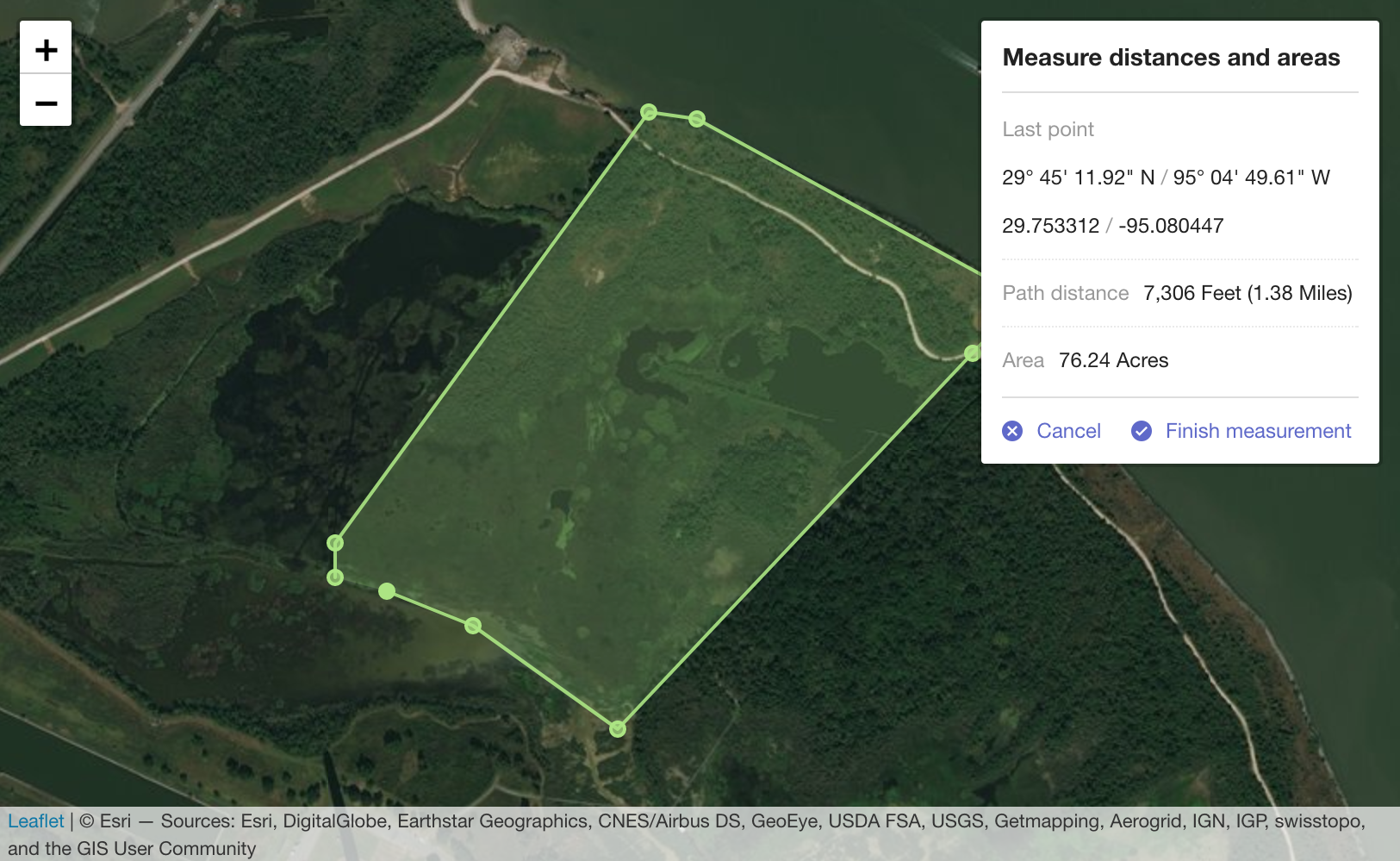\r\n\r\n
\r\n## Usage\r\n\r\nTODO. Add usage\r\n\r\n\r\n## Add control to a Leaflet map\r\n\r\n`leaflet-measure` adds `L.Control.Measure`. This control may be used with the standard Leaflet control workflows [described in the Leaflet docs](http://leafletjs.com/reference.html#control).\r\n\r\nThe measure control can be instantiated directly and added to a map:\r\n```javascript\r\nvar myMap = L.map('mapElementId', options);\r\nvar measureControl = new L.Control.Measure(options);\r\nmeasureControl.addTo(myMap);\r\n```\r\n\r\nor instantiated via the factory:\r\n```javascript\r\nvar myMap = L.map('mapElementId', options);\r\nvar measureControl = L.control.measure(options);\r\nmeasureControl.addTo(myMap);\r\n```\r\n\r\nor added to a map using map options:\r\n```javascript\r\nvar myMap = L.map('mapElementId', {\r\n measureControl: true\r\n});\r\n```\r\n\r\n
\r\n\r\n\r\n## Control options\r\n\r\n### position\r\n\r\n`{ position: 'topright' }`\r\n\r\nStandard Leaflet control [position options](http://leafletjs.com/reference.html#control-positions)\r\n\r\n### primaryLengthUnit | secondaryLengthUnit\r\n\r\n`{ primaryLengthUnit: 'feet', secondaryLengthUnit: 'miles' }`\r\n\r\nUnits used to display length results. `secondaryLengthUnit` is optional.\r\n\r\nValid values are `feet`, `meters`, `miles`, and `kilometers`\r\n\r\n### primaryAreaUnit | secondaryAreaUnit\r\n\r\n`{ primaryAreaUnit: 'acres', secondaryAreaUnit: undefined }`\r\n\r\nUnits used to display area results. `secondaryAreaUnit` is optional.\r\n\r\nValid values are `acres`, `hectares`, `sqfeet`, `sqmeters`, and `sqmiles`\r\n\r\n### activeColor\r\n\r\n`{ activeColor: '#ABE67E' }`\r\n\r\nBase color to use for map features rendered while actively performing a measurement. Value should be a color represented as a hexadecimal string.\r\n\r\n### completedColor\r\n\r\n`{ completedColor: '#C8F2BE' }`\r\n\r\nBase color to use for features generated from a completed measurement. Value should be a color represented as a hexadecimal string.\r\n\r\n### popupOptions\r\n\r\n`popupOptions: { className: 'leaflet-measure-resultpopup', autoPanPadding: [10, 10] }`\r\n\r\nOptions applied to the popup of the resulting measure feature. Properties may be any standard Leaflet [popup options](http://leafletjs.com/reference.html#popup-options).\r\n\r\n### units\r\n\r\nCustom units to make available to the measurement calculator. Packaged units are `feet`, `meters`, `miles`, and `kilometers` for length and `acres`, `hectares`, `sqfeet`, `sqmeters`, and `sqmiles` for areas. Additional unit definitions can be added to the packaged units using this option.\r\n\r\nDefine units as\r\n\r\n```javascript\r\n{\r\n someNewUnit: {\r\n factor: 0.001, // Required. Factor to apply when converting to this unit. Length in meters or area in sq meters will be multiplied by this factor.\r\n display: 'My New Unit', // Required. How to display in results, like.. \"300 Meters (0.3 My New Unit)\".\r\n decimals: 2 // Number of decimals to round results when using this unit. `0` is the default value if not specified.\r\n },\r\n myOtherNewUnit: {\r\n factor: 1234,\r\n display: 'My Other Unit',\r\n decimals: 0\r\n }\r\n}\r\n```\r\n\r\n### captureZIndex\r\n\r\n`{ captureZIndex: 10000 }`\r\n\r\nZ-index of the marker used to capture measure clicks. Set this value higher than the z-index of all other map layers to disable click events on other layers while a measurement is active.\r\n\r\n### decPoint | thousandsSep\r\n\r\n`{ decPoint: '.', thousandsSep: ',' }`\r\n\r\nDecimal point and thousands separator used when displaying measurements. If not specified, values are defined by the localization.\r\n\r\n
\r\n\r\n\r\n## Events\r\n\r\nYou can subscribe to the following events on the [Map](http://leafletjs.com/reference.html#map-class) using [these methods](http://leafletjs.com/reference.html#events)\r\n\r\n### measurestart\r\n\r\nFired when measurement starts\r\n\r\n### measurefinish\r\n\r\nFired when measurement finishes with results of the measurement. Results data includes:\r\n\r\n- `area`: Area of a polygon measurement in sq meters. 0 for measurements with less than 3 points.\r\n\r\n- `areaDisplay`: Area formatted as displayed in the popup.\r\n\r\n- `lastCoord`: Last point clicked in both decimal degrees and degress/min/seconds.\r\n\r\n- `length`: Length of the measurement in meters. 0 for measurements with less than 2 points.\r\n\r\n- `lengthDisplay`: Length formatted as displayed in the popup.\r\n\r\n- `pointCount`: Number of points directly added by the user.\r\n\r\n- `points`: Array of points as [`LatLng`](http://leafletjs.com/reference.html#latlng) used to calculate the measurement. Number of items in the array may differ from `pointCoint` because an additional point is added to close polygons during polygon measurements.\r\n\r\n
\r\n\r\n\r\n## Customizing map feature styles\r\n\r\nMap features may be styled using CSS SVG style attributes. Features generated from `leaflet-measure` measurements are given the following class names:\r\n\r\n- **layer-measurearea**: Feature displaying area of an active measurement\r\n\r\n- **layer-measureboundary**: Feature displaying the linear path of an active measurement\r\n\r\n- **layer-measurevertex**: Feature added at each vertex (measurement click) of an active measurement\r\n\r\n- **layer-measuredrag**: Symbol following cursor while moving during an active measurement\r\n\r\n- **layer-measure-resultarea**: Feature added to the map as a permanent layer resulting from an area (3+ points) measurement\r\n\r\n- **layer-measure-resultline**: Feature added to the map as a permanent layer resulting from a linear (2 point) measurement\r\n\r\n- **layer-measure-resultpoint**: Featured added to the map as a permanent layer resulting from a point (single click) measurement\r\n\r\n
\r\n\r\n## Development\r\n\r\nThe build process uses npm (Node Package Management) which comes with Node.js.\r\n\r\nAfter you have Node.js installed you can do ```npm install``` to install dependencies and ```npm run-script start:dev``` to initialize a local server (localhost:8080) for leaflet-measure assets.\r\n\r\nIt detects modifications on source files and re-compiles to /leaflet-measure.css and /leaflet-measure.js.\r\n\r\n## Distribuition Build\r\n\r\nWith npm installed do ```npm install``` to install dependencies and ```npm run-script build``` to generate dist/leaflet-measure.css and dist/leaflet-measure.js.\r\n\r\nIt will also generate dist/leaflet-measure.{locale}.js files for each localization available.\r\n\r\n## Internationalization\r\n\r\nTODO. Internationalization\r\n","readmeFilename":"README.md"}